
Regional guide · New Jersey
Bulkheads & Seawalls on the Jersey Shore
Bulkheads on the Jersey Shore's bays and lagoons in Monmouth, Ocean, Atlantic and Cape May counties: tides, Sandy flooding and NJ coastal general permits.
Last reviewed by the Bulkhead Walls Editorial Team
Overview
Jersey Shore bulkheads line man-made lagoons, bayfront lots and tidal rivers behind the barrier islands. Tides range from over 4 feet at the ocean inlets to under 1 foot in upper Barnegat Bay. New Jersey's coastal rules include general permits for bulkheads on lagoons, at single-family lots and for reconstruction of existing bulkheads.
- Communities covered
- Monmouth County, Ocean County, Atlantic County, Cape May County, Toms River, Long Beach Island, Atlantic City, Ocean City, Cape May
- Waterbodies
- Barnegat Bay, Little Egg Harbor, Great Bay, Great Egg Harbor Bay, Manasquan River, Shrewsbury and Navesink rivers, Atlantic Ocean, man-made lagoons
- Water types
- saltwater, brackish, tidal
Key local considerations
- NJ coastal general permits address bulkheads on man-made lagoons (GP 6), reconstruction of existing bulkheads (GP 10) and new bulkheads at single-family or duplex lots (GP 14).
- Reconstruction under GP 10 can sit up to 18 inches outshore for timber or 24 inches for vinyl abutting existing pilings, under conditions.
- Mean tide range is about 4.0 feet at Atlantic City and 4.9 feet at Cape May, but about 0.8 feet at Toms River, per NOAA.
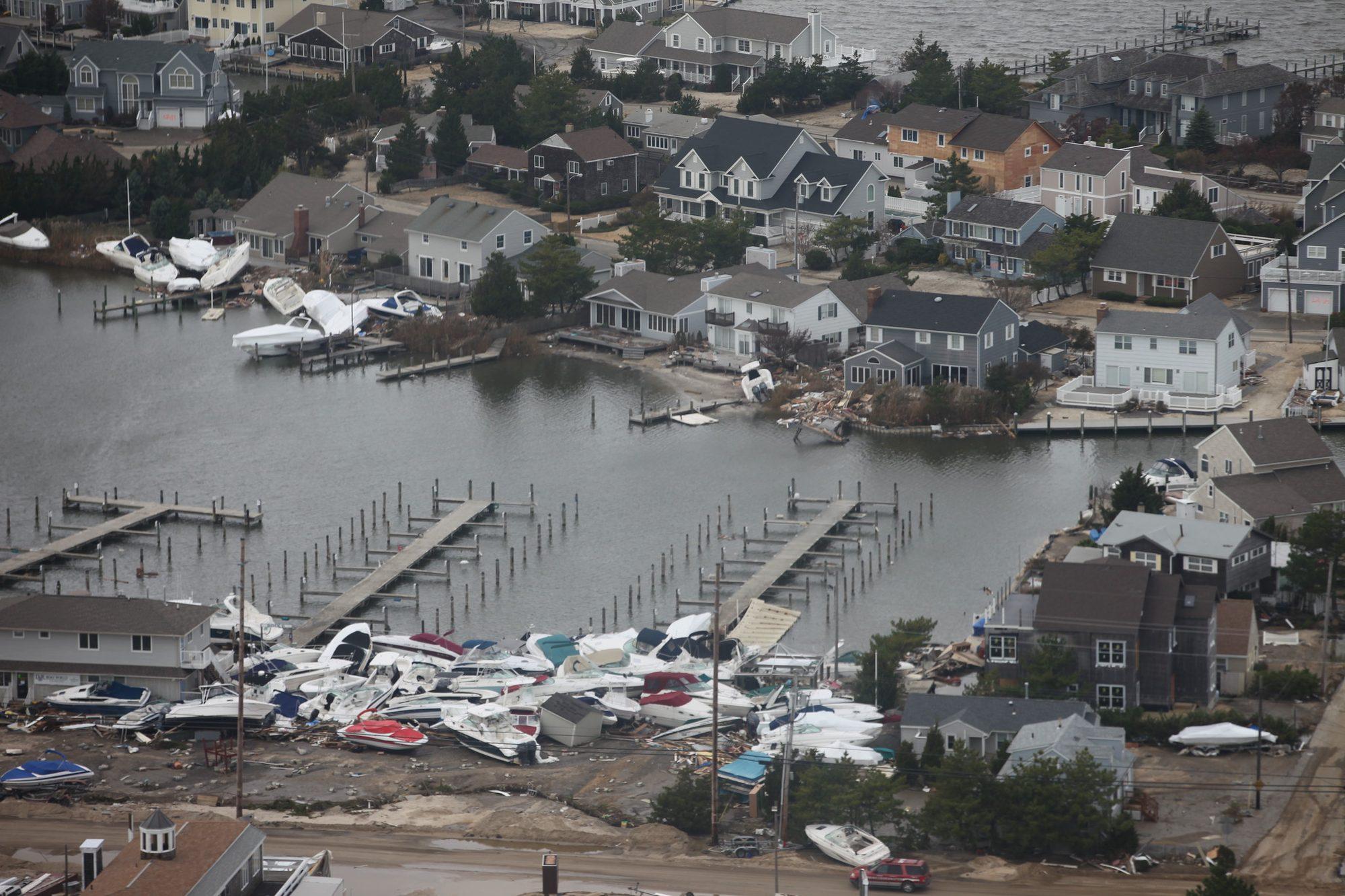
- Hurricane Sandy (2012) inundated and in places breached barrier islands in Monmouth and Ocean counties.
- Bulkheads subject to wave runup (V zones) must be designed and certified by a professional engineer under GP 10.
The Jersey Shore runs from Sandy Hook in Monmouth County to Cape May. Behind the ocean beaches lie shallow bays, tidal rivers and dredged lagoon neighborhoods where bulkheads hold up yards, docks and streets. This page covers the bay and lagoon side of the shore in Monmouth, Ocean, Atlantic and Cape May counties.
The waterfront environment
Bays, rivers and lagoons
In Monmouth County, the Shrewsbury and Navesink rivers and the Manasquan River are the main tidal waters. Barnegat Bay and Little Egg Harbor stretch behind Island Beach and Long Beach Island in Ocean County. Farther south, Great Bay, Great Egg Harbor Bay and the back bays of Atlantic and Cape May counties sit behind Brigantine, Absecon Island, Ocean City and the Wildwoods. New Jersey's coastal rules include a general permit specifically for bulkheads on "substantially developed" man-made lagoons.
Tide range varies with inlet access
NOAA tidal datums show how much the tide changes from the ocean inlets to the upper bays:
| Station | Mean tide range |
|---|---|
| Cape May | about 4.9 feet |
| Sandy Hook | about 4.7 feet |
| Atlantic City | about 4.0 feet |
| Barnegat Inlet (inside) | about 2.2 feet |
| Toms River | about 0.8 feet |
A lagoon bulkhead near an inlet can see several feet of daily water movement and stronger currents; one in upper Barnegat Bay sees much less. Small daily tides do not mean small risk. In enclosed bays, wind and storms can push water levels far above normal. Exposure, currents and soil conditions should all inform design. See how bulkhead walls work and seawall drainage.
Storm history
Sandy made landfall as a post-tropical cyclone near Brigantine, New Jersey, in October 2012. The National Hurricane Center reported that water levels were highest along the northern Jersey Shore in Monmouth and Ocean counties, north of the landfall point:
- Barrier islands were almost completely inundated in some areas, and breached in some cases, as ocean surge and waves met rising water from back bays such as Barnegat Bay and Little Egg Harbor.
- The USGS surveyed high-water marks as high as 4 to 5 feet above ground level in Sea Bright in Monmouth County and in Tuckerton, Seaside Park and Long Beach Island in Ocean County.
- Inundation reached 2 to 4 feet in areas near Atlantic City and Cape May. The NOS gauges at Atlantic City and Cape May measured storm surges of 5.82 and 5.16 feet.
Bayfront bulkheads can be overtopped from the bay side during an event like this, then lose backfill as water drains. Review signs of bulkhead failure and why a yard sinks behind a seawall.
Permitting on the Jersey Shore
NJDEP coastal permits
The New Jersey Department of Environmental Protection, Division of Land Resource Protection, administers the Coastal Zone Management Rules at N.J.A.C. 7:7. Under the waterfront development provisions, the regulated area includes tidal waterways and the lands beneath them up to mean high water and, in some areas, adjacent uplands within 100 feet of mean high water, extending up to 500 feet in some cases.
The rules include several coastal general permits that bear directly on bulkheads. The published text includes:
| General permit | Summary of what it covers |
|---|---|
| GP 6 | A new bulkhead on a lot on a substantially developed man-made lagoon, located inshore of wetlands, with returns at each end unless tied into an adjacent bulkhead |
| GP 10 | Reconstruction of a legally existing functioning bulkhead in place or upland, or within 18 inches outshore for timber or 24 inches for vinyl abutting the existing pilings (on lagoon lots, in place or upland only) |
| GP 14 | A bulkhead at a single-family or duplex lot on a natural water body where legally existing bulkheads are on adjacent lots no more than 75 feet apart, at or above the spring high water line and at least five feet inshore of wetlands |
| GP 17 | Vegetative stabilization of eroded shorelines along tidal waterways other than the Atlantic Ocean |
Each permit carries more conditions than shown here. GP 10, for example, requires bulkheads subject to wave runup forces (V zones) to be designed and certified by a professional engineer, and it limits riprap at the toe to what the Department finds necessary to limit scour. Rules are amended periodically, so confirm current text and eligibility with NJDEP.
Federal and local review
The U.S. Army Corps of Engineers reviews work in waters of the United States; New Jersey is split between the Philadelphia and New York districts, so confirm which covers the property. Municipal construction offices issue local permits and apply flood damage prevention rules. Structures on state-owned tidelands may need a tidelands instrument from NJDEP. Our Permit Navigator lists the agency pages for New Jersey.
Planning a project here
- Identify the setting: man-made lagoon, natural bay or river shoreline, or oceanfront. The applicable general permit depends on it.
- Find out whether the existing bulkhead is legally existing and functioning; that affects reconstruction options.
- Ask the designer whether the site is in a V zone and how scour at the toe will be handled.
- Use the bulkhead permit guide, vinyl bulkheads, timber bulkheads and how to compare contractor quotes.
This page is educational. NJDEP, the Corps and the municipality decide what a specific project requires.
Frequently asked questions
Can I replace my bulkhead in front of the old one in New Jersey?
New Jersey's general permit for reconstructing a legally existing functioning bulkhead allows, under conditions, placement within 18 inches outshore for timber or up to 24 inches for vinyl abutting the existing pilings, except on lagoon lots where it must be in place or upland. NJDEP decides whether a project qualifies.
Why are tides so small in parts of Barnegat Bay?
The bay connects to the ocean through a few inlets, which damp the tide. NOAA datums show about 2.2 feet of mean range inside Barnegat Inlet and about 0.8 feet at Toms River.
How high was the water on the Jersey Shore during Sandy?
The National Hurricane Center reported high-water marks of 4 to 5 feet above ground in places such as Sea Bright, Tuckerton, Seaside Park and Long Beach Island, and 2 to 4 feet near Atlantic City and Cape May.
Is a living shoreline an option in New Jersey?
New Jersey's coastal rules include general permits for vegetative stabilization of eroded shorelines along tidal waterways other than the Atlantic Ocean and for living shoreline activities. Site exposure determines whether one is practical.
Sources
- 1N.J. Admin. Code Title 7, Chapter 7, Subchapter 6 — Coastal General Permits — Legal Information Institute, Cornell Law School. Accessed November 3, 2026.
- 2N.J. Admin. Code § 7:7-6.6 — General permit 6: bulkhead on a man-made lagoon — Legal Information Institute, Cornell Law School. Accessed November 3, 2026.
- 3N.J. Admin. Code § 7:7-6.10 — General permit 10: reconstruction of a legally existing functioning bulkhead — Legal Information Institute, Cornell Law School. Accessed November 3, 2026.
- 4N.J. Admin. Code § 7:7-6.14 — General permit 14: bulkhead at a single-family home or duplex lot — Legal Information Institute, Cornell Law School. Accessed November 3, 2026.
- 5N.J. Admin. Code § 7:7-6.17 — General permit 17: stabilization of eroded shorelines — Legal Information Institute, Cornell Law School. Accessed November 3, 2026.
- 6Tropical Cyclone Report: Hurricane Sandy (AL182012) — NOAA National Hurricane Center. Accessed November 3, 2026.
- 7Datums for 8531680, Sandy Hook, NJ — NOAA Tides & Currents. Accessed November 3, 2026.
- 8Datums for 8533615, Barnegat Inlet, USCG Station, NJ — NOAA Tides & Currents. Accessed November 3, 2026.
- 9Datums for 8533051, Toms River, NJ — NOAA Tides & Currents. Accessed November 3, 2026.
- 10Datums for 8534720, Atlantic City, NJ — NOAA Tides & Currents. Accessed November 3, 2026.
- 11Datums for 8536110, Cape May, NJ — NOAA Tides & Currents. Accessed November 3, 2026.
Educational guidance only. This information is general and is not a structural assessment, engineering advice, or a permitting determination. Conditions at every waterfront are different; consult a licensed marine contractor or professional engineer about your wall.